Cap de Creus is the easternmost point of the Iberian Peninsula and one of the wildest seascapes on the entire Costa Brava. Seen from land, it impresses. Seen from the water, aboard a boat, it's something else entirely.
This guide describes the route we regularly follow from the Santa Margarita canals to the coves of Cap de Creus: what to expect at each stage, the best stops, where to eat and what to know before setting off. Whether you plan to rent a boat independently or prefer to come with a skipper, this information will be useful.
Why Cap de Creus is the best destination from Roses by boat
From Roses, Cap de Creus is about 45–60 minutes by boat depending on the model and sea conditions. It's a perfect distance: far enough for the trip to feel substantial, close enough to enjoy without rushing.
What makes this route special isn't only the destination — it's the journey. The northern Costa Brava coastline between Roses and Cap de Creus is a landscape of cliffs, hidden coves and water clarity that is hard to find anywhere in the western Mediterranean. Most of these coves are inaccessible by land or require long hikes on mountain paths. By boat, you arrive directly.
Moreover, the entire area falls within the Cap de Creus Natural Park, meaning the waters are protected, fishing is regulated and the marine ecosystem is in exceptional condition. It's no coincidence that snorkelling here is among the best on the Costa Brava.
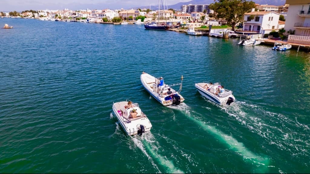
The departure point — the Santa Margarita canals
We always depart from the Santa Margarita Marina at the entrance to Roses. The first minutes of the route pass through the canals themselves — a 20–25-minute journey along inland waterways that are already a spectacle in their own right.
On both sides of the canals, over 500 homes have direct water access with their own private pontoons. It's an environment completely different from what you'd expect of the Costa Brava, and one that many visitors discover for the first time on this route. For those who don't know the canals, this first section tends to be one of the highlights of the day.
On leaving the canals, you enter the Bay of Roses. From here, Cap de Creus appears in the distance and the northward route is unmistakable.
The route step by step — from the canals to Cap de Creus
There is no single fixed route. The journey adapts to sea conditions, available time and each group's preferences. But there is a sequence that works well for most departures:
- Santa Margarita canals — Depart from the marina, navigate the inner canals to the Bay of Roses. Low speed, sheltered waters, ideal for warming up.
- Bay of Roses — Cross the bay northward. The landscape begins to change: the Pyrenees in the background, the coastline grows more dramatic and the water more transparent.
- First cove — Depending on conditions, the first stop is usually Cala Jóncols or Cala Rostella. Anchor, swim, snorkel.
- Cala Pelosa — Lunch stop if the day allows. The Cala Pelosa beach bar serves until sold out, so the earlier you arrive the better.
- Cap de Creus — The final point. The landscape here is completely different: bare rock, impossibly coloured water and the feeling of being at the edge of something.
- Return — The journey back usually takes place with the sun already low. The snow-capped Pyrenees (in spring) or the silhouette of Roses in the distance make the return just as beautiful as the outward trip.
The essential coves on the route
Between Roses and Cap de Creus there are dozens of coves. These three are the ones we include in almost every route:
Cala Pelosa
Small and sheltered, with fine sandy bottom and intense turquoise water. It's the best-known stop on the route and the only one with a restaurant directly on the beach. Perfect for anchoring and swimming.
Cala Rostella
Better protected from the north wind than other coves in the area. Its waters are particularly clear thanks to posidonia seagrass beds, which filter the water and give it that characteristic emerald green colour.
Cala Jóncols
One of the largest coves on the route, difficult to access by land but perfectly reachable by boat. Its waters are ideal for family swimming. The setting of pine trees reaching down to the shore makes it especially photogenic.
The Cala Pelosa beach bar — unmissable food stop
Cala Pelosa has a beach bar that has been a fixed stop on Cap de Creus routes for years. The cuisine is product-driven Mediterranean: rice dishes, fideuà and fresh fish cooked to order, with boats anchored just a few metres away.
This isn't a place to rush. The experience is sitting on the terrace over the water, with the boat tied up nearby and as much time as you need. It's exactly the kind of pause a day on the water should include.
One important note: the beach bar doesn't take reservations and space is limited. In July and August, if you arrive after 14:00, you'll likely have to wait or find it full. In shoulder season (May, June, September) it's far less of an issue.
What you should know before heading to Cap de Creus
The Cap de Creus route is stunning, but it has a few particularities worth knowing before you set off.
The Tramuntana wind
Cap de Creus is one of the most exposed areas of the Costa Brava to the Tramuntana, the north wind that can whip up the sea within hours. On days with Tramuntana forecast, we cancel or modify the route at no cost. It's not a decision we take lightly — it's a safety matter.
Posidonia seagrass
The posidonia meadows are responsible for the exceptional clarity of the water around Cap de Creus. It's a protected species and a fundamental ecosystem. In posidonia zones you cannot anchor — there are moorings (fixed mooring buoys) in the coves designated for this purpose.
Submerged rocks
The Cap de Creus coastline has many rocks at shallow depth, especially at cove entrances. If you're going on your own boat, always navigate slowly when approaching the coast and consult the nautical chart. If you're coming with our skippered service, the skipper knows this coast inside out and handles all navigation.
With a licence, without a licence or with a skipper?
The Cap de Creus route can be done in three different ways:
- No-licence boat — No-licence boats are perfect for the Santa Margarita canals and the Bay of Roses. To reach Cap de Creus, sea conditions need to be favourable. In good conditions, it's perfectly possible to reach the first coves of the route.
- Licensed boat — With a more powerful vessel and a nautical licence, the full Cap de Creus route is entirely accessible. Greater range, higher speed and more route options.
- Private excursion with skipper — The option where you don't worry about anything. The skipper knows every cove and every rock on this coast. The route adapts to the group and the day. It's the most comfortable way to do the full route, especially if it's your first time in the area.
Private excursion to Cap de Creus with skipper
The skipper takes you to the coves. You just enjoy. Route tailored to your group.